Atlas 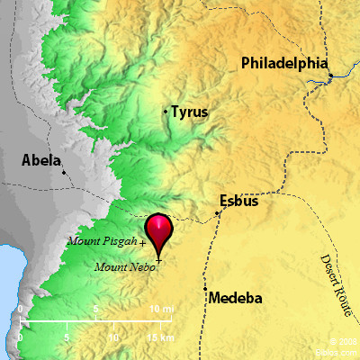 Mount Nebo and surrounding area
Maps Created using Biblemapper 3.0Additional data from OpenBible.info
You are free to use up to 50 Biblos coprighted maps (small or large) for your website or presentation. Please credit Biblos.com. Occurrences Deuteronomy 32:49 "Go up into this mountain of Abarim, to Mount Nebo, which is in the land of Moab, that is over against Jericho; and see the land of Canaan, which I give to the children of Israel for a possession; Deuteronomy 34:1 Moses went up from the plains of Moab to Mount Nebo, to the top of Pisgah, that is over against Jericho. Yahweh showed him all the land of Gilead, to Dan, Encyclopedia NEBO, MOUNT(har nebho; Nabau): A mountain in the land of Moab which Moses ascended at the command of God in order that he might see the Land of Promise which he was never to enter. There also he was to die. From the following passages (namely, Numbers 33:47 Deuteronomy 32:49; Deuteronomy 34:1), we gather that it was not far from the plain of Moab in which Israel was encamped; that it was a height standing out to the West of the mountains of Abarim; that it lay to the East of Jericho; and that it was a spot from which a wide and comprehensive view of Palestine could be obtained. None of these conditions are met by Jebel `Attarus, which is too far to the East, and is fully 15 miles South of a line drawn eastward from Jericho. Jebel 'Osha, again, in Mt. Gilead, commands, indeed, an extensive view; but it lies too far to the North, being at least 15 miles North of a line drawn eastward from Jericho. Both of these sites have had their advocates as claimants for the honor of representing the Biblical Nebo.
The "head" or "top" of Pisgah is evidently identical with Mt. Nebo (Deuteronomy 34:1). After Moses' death he was buried "in the valley in the land of Moab," over against Beth-peor.
The name Neba is found on a ridge which, some 5 miles Southwest of Hesban and opposite the northern end of the Dead Sea, runs out to the West from the plateau of Moab, "sinking gradually: at first a broad brown field of arable land, then a flat top crowned by a ruined cairn, then a narrower ridge ending in the summit called Siagbah, whence the slopes fall steeply on all sides. The name Nebo or Neba (the "knob" or "tumulus") applies to the flat top with the cairn, and the name Tal`at es-Sufa to the ascent leading up to the ridge from the North. Thus we have three names which seem to connect the ridge with that whence Moses is related to have viewed the Promised Land, namely, first, Nebo, which is identically the same word as the modern Neba; secondly, Siaghah, which is radically identical with the Aramaic Se`ath, the word standing instead of Nebo in the Targum of Onkelos (Numbers 32:3), where it is called the burial place of Moses; thirdly, Tal`at es-Sufa, which is radically identical with the Hebrew Zuph (tsuph), whence Mizpah (mitspah) and Zophim (tsophim..... The name Pisgah is not now known, but the discovery of Zophim (compare Numbers 23:14) confirms the view now generally held, that it is but another title of the Nebo range."
Neither Mt. Hermon nor Dan (Tell el-Qady) is visible from this point; nor can Zoar be seen; and if the Mediterranean is the hinder sea, it also is invisible. But, as Driver says ("Dt," ICC, 419), the terms in Deuteronomy 34:1, 3 are hyperbolical, and must be taken as including points filled in by the imagination as well as those actually visible to the eye. Mr. Birch argues in favor of Tal`at el-Benat, whence he believes Dan and Zoar to be visible, while he identifies "the hinder sea" with the Dead Sea (PEFS, 1898, 110;).
W. Ewing |